

Newsroom
-
 SDGSAT-1 Nighttime Thermal Infrared Observations Promote High-Resolution Dynamic Surface Water Mapping in Hindu Kush Himalaya
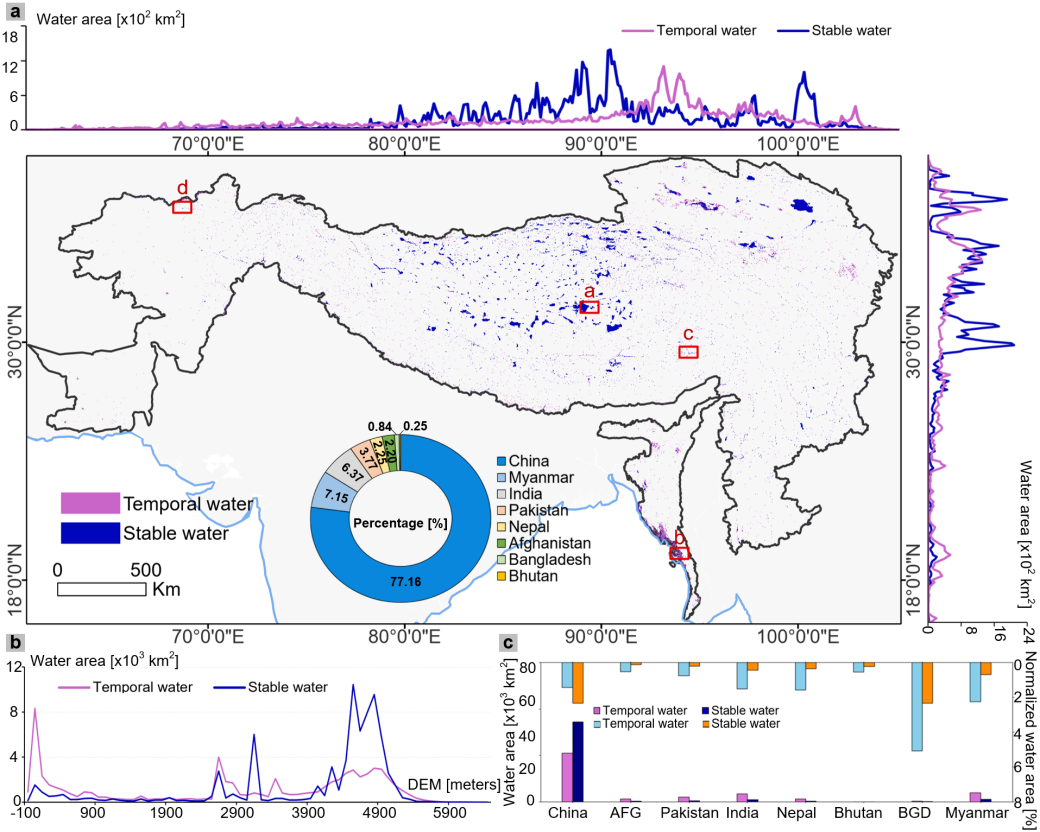
A study published in Remote Sensing of Environment has generated the first 10-meter dynamic water dataset (DWH10) for the Hindu Kush Himalaya (HKH) region, revealing that existing global water products may substantially underestimate surface water extent in mountainous areas.
17 Jun 2026 -
 In Vitro Biological Neuronal Networks Offer Blueprint for Low-Power, High-Speed AI Computing
A research team led by Prof. CAI Xinxia, Assoc. Prof. LUO Jinping and Assoc. Prof. WANG Mixia from the Aerospace Information Research Institute of the Chinese Academy of Sciences (AIRCAS) has demonstrated that in vitro biological neuronal networks can achieve both low-power consumption and high-speed communication through predictable electrical stimulation, providing a promising new route for next-generation brain-inspired computing systems. The study shows that regular stimulation increased neural communication speed by about 1.79 times without adding extra energy cost.
20 May 2026 -
 Global Report Reveals Climate Risks to UNESCO-designed Sites
A UNESCO report released on 21 April 2026, People and Nature in UNESCO-designated Sites: Global and Local Contributions, delivers the first global assessment of over 2,260 World Heritage sites, Biosphere Reserves and Global Geoparks. The study finds that more than one in four sites could reach critical ecological tipping points by 2050 if pressures intensify, while also showing that monitored wildlife populations within these sites have remained stable on average, contrasting sharply with a 73% global decline since 1970.
09 May 2026 -
 China-developed Knowledge-guided AI Algorithm Offers Promising Results in Global Soil Moisture Management
Researchers from the Aerospace Information Research Institute under the Chinese Academy of Sciences (AIRCAS) have developed a knowledge-guided artificial intelligence algorithm that significantly improves the resolution of global soil moisture observation.
09 May 2026 -
 Unified Weakly Supervised Learning Framework Advances LiDAR Remote Sensing for Earth Observation
A research team from the Aerospace Information Research Institute of the Chinese Academy of Sciences (AIRCAS), in collaboration with Changsha University of Science and Technology, and Tsinghua University, has proposed a systematic and unified framework that integrates Light Detection and Ranging (LiDAR) remote sensing with Weakly Supervised Learning (WSL). The study provides a comprehensive review that bridges the traditional gap between LiDAR data interpretation and large-scale parameter inversion, offering scalable solutions to reduce the high costs of manual data annotation in Earth observation.
30 Apr 2026 -
 China's Fengyun Satellites Enable Breakthrough in Mapping Underground Soil Temperatures Worldwide
A recent study published in the ISPRS Journal of Photogrammetry and Remote Sensing, describes a physics-based framework that maps global subsurface soil temperature profiles by harnessing the multi-overpass capabilities of China's Fengyun (FY) meteorological satellites. This work was led by Prof. ZHAO Tianjie from the Laboratory of Earth Observation for Water at the Aerospace Information Research Institute of the Chinese Academy of Sciences (AIRCAS).
27 Apr 2026

