

Newsroom
-
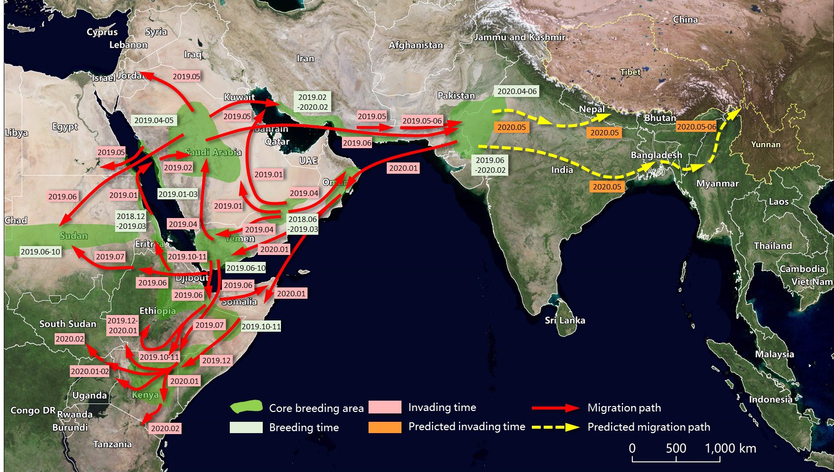 CAS Scientists Assess Risk of Desert Locust Invasion to China, Based on Remote Sensing Monitoring
A research team led by Prof. HUANG Wenjiang and Dr. DONG Yingying from the Aerospace Information Research Institute (AIR) under the Chinese Academy of Sciences (CAS) has tracked the migration path of the Desert Locust and make a detailed analysis on the possibility of the Desert Locust invasion of China. The research combines multi-source Earth Observation data (including GF series in China, MODIS and Landsat series in US, and Sentinel series in EU), meteorological data, field data, and self-developed models and algorithms for Desert Locust monitoring and forecasting based on the Digital Earth Science Platform developed by AIR.
25 Feb 2020 -
 Progress in China-Mymmar Joint Remote Sensing Survey and Mapping of Bagan World Heritage Site
At the invitation of the Department of Archaeology and National Museum (Bagan Branch), the Ministry of Religious Affairs and Culture, Myanmar, the DBAR-Heritage World Natural and Cultural Heritage Working Group(WG) carried out the UAV-based optical remote sensing survey in Bagan World Heritage Site from December 25, 2019 to January 6, 2020. During the period of field work, with the support of Myanmar, the Chinese scientific research team carried out 17 UAV flights which covered about 1000 kilometers of flight lines and 240 square kilometers of heritage area, and obtained approximately 266 GB of raw aerial remote sensing data with ground sample distance better than 10 cm.
19 Feb 2020 -
AIR Launches National Key R&D Program in Support of 2022 Winter Olympic Games
A National Key R & D Program featuring "Science and Technology in Support of Beijing 2022 Winter Olympics” was kicked off in Beijing on January 7, 2020. The program, which is undertaken by a research team led by Prof. SHAO Yun from the Aerospace Information Research Institute (AIR), aims to assess the environmental conditions of the training venues, in particular the impact of winds on the performances of athletes, and therefore assist to build an on-site support system.
18 Feb 2020 -
 Projects Join to Assess Arctic Environment, Safeguard Scientific Expedition and Shipping
A joint inter-project meeting on the Arctic Shipping and its assessment was attended by nearly 20 backbone scientists from two national key R&D projects to report, exchange and discuss their researches and progresses about this topic in the year of 2019.
17 Feb 2020 -
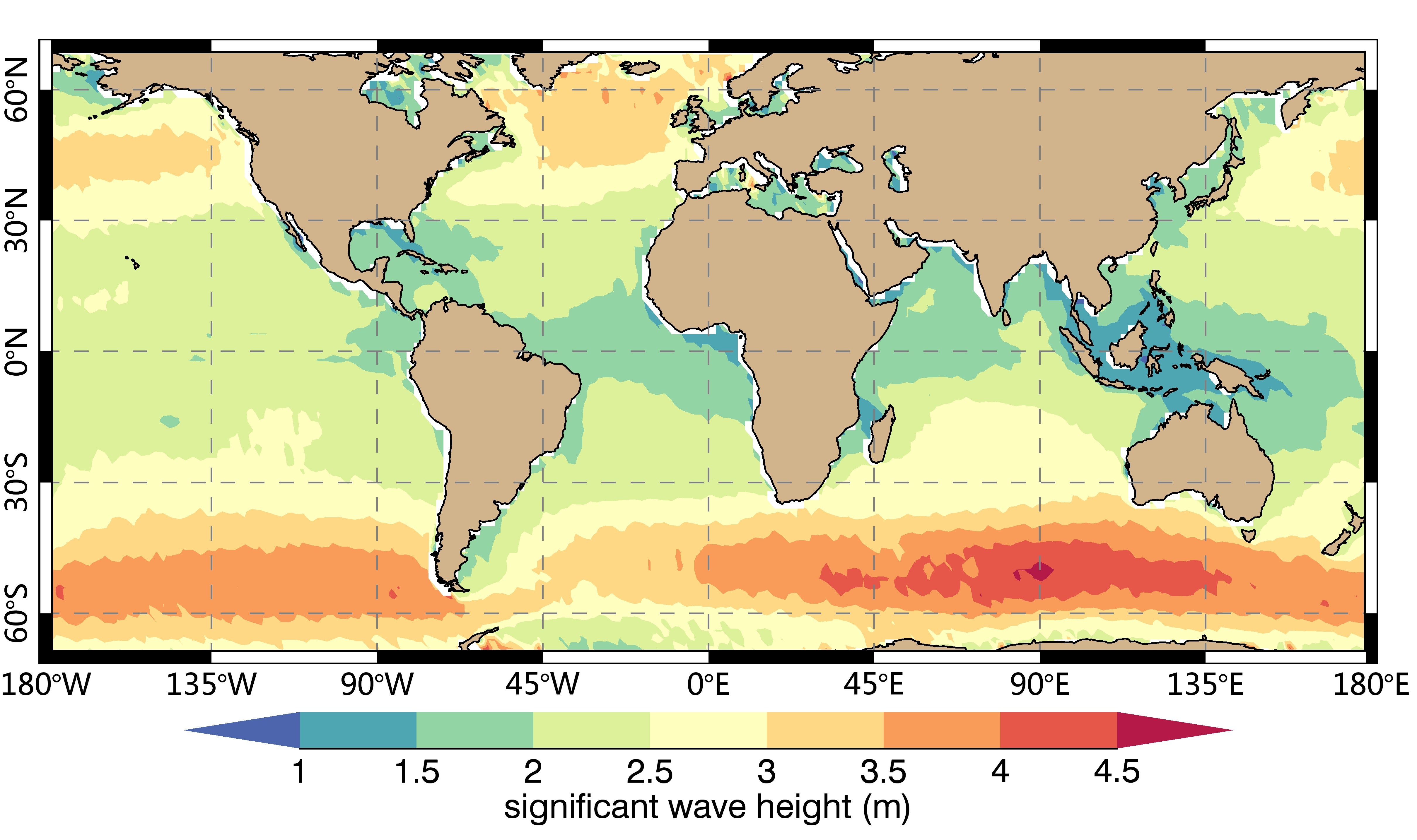 AIR Scientists Release Global Sea State Dataset
A global sea state dataset based on the ENVISAT/ASAR wave mode data has been recently released by the scientists from the Aerospace Information Research Institute (AIR) under the Chinese Academy of Sciences (CAS). The dataset derived from decadal spaceborne Synthetic Aperture Radar (SAR) data is the first of this kind that describes global sea state in terms of ocean wave integral parameters of significant wave height and mean wave period.
14 Feb 2020 -
 R&D Center for Aerostat System Wins Excellent Team Award for the Construction of LHAASO
A review meeting on the construction of Large High Altitude Air Shower Observatory (LHAASO) was held in Chengdu on December 24, 2019. The engineering team from the R&D Center for Aerostat System (hereafter called the “Center”) under the Aerospace Information Research Institute (AIR) in charge of the engineering and construction of LHAASO project won the Excellent Team Award of 2019.
18 Jan 2020

