AIRCAS Researchers Reveal Supershear Rupture Mechanism of 2025 Mw 7.8 Myanmar Earthquake
On March 28, 2025, a moment magnitude (Mw) 7.8 earthquake struck the Mandalay region of Myanmar, rupturing about 510 km of the Sagaing Fault. The southern segment propagated at supershear speed over~450 km, making it one of the longest continental supershear ruptures ever observed. Using satellite remote sensing integrated with seismic observations, an international research team led by Professor MENG Lingsen from the University of California, Los Angeles and Professor ZHANG Yunjun from the Aerospace Information Research Institute of the Chinese Academy of Sciences (AIRCAS), successfully reconstructed the rupture process and mapped earthquake damage in unprecedented detail. The results were published in Science on October 30, 2025, and selected as a cover article.

Cover of Science, October 30, 2025. (Image courtesy of Science)
Due to limited ground access in the affected region, satellite remote sensing served as the primary data source for the investigation. The team used synthetic aperture radar (SAR) data from the LuTan-1 satellite, whose main payload was developed by AIRCAS, together with SAR observations from Sentinel-1 and ALOS-2. Using the interferometric SAR (InSAR) technique, researchers derived a high-resolution coseismic surface deformation field. By jointly inverting these deformatioin data with seismic records, they reconstructed the fault slip distribution and rupture history of the earthquake.
The analysis shows that the rupture propagated at a speed of about 5.0 km/s, exceeding the local shear-wave velocity, confirming sustained supershear behavior along a continental strike-slip fault. The analysis further indicate that fault geometry, long-term stress accumulation, and material contrasts across the fault were key factors enabling large-scale supershear rupture.
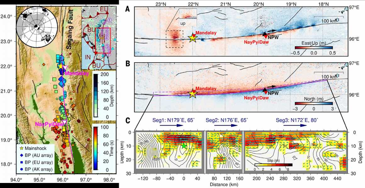
Earthquake overview (left) and ground deformation with slip model (right). (Image by AIRCAS)
Beyond rupture dynamics, AIRCAS researchers also conducted satellite-based damage assessments, which are concentrated along the fault, especially in urban areas such as Mandalay. Combined with high-resolution optical images from satellites including Jilin-1 and Gaofen series, the team identified the spatial distribution of secondary hazards, such as building collapses, soil liquefaction, and landslides.
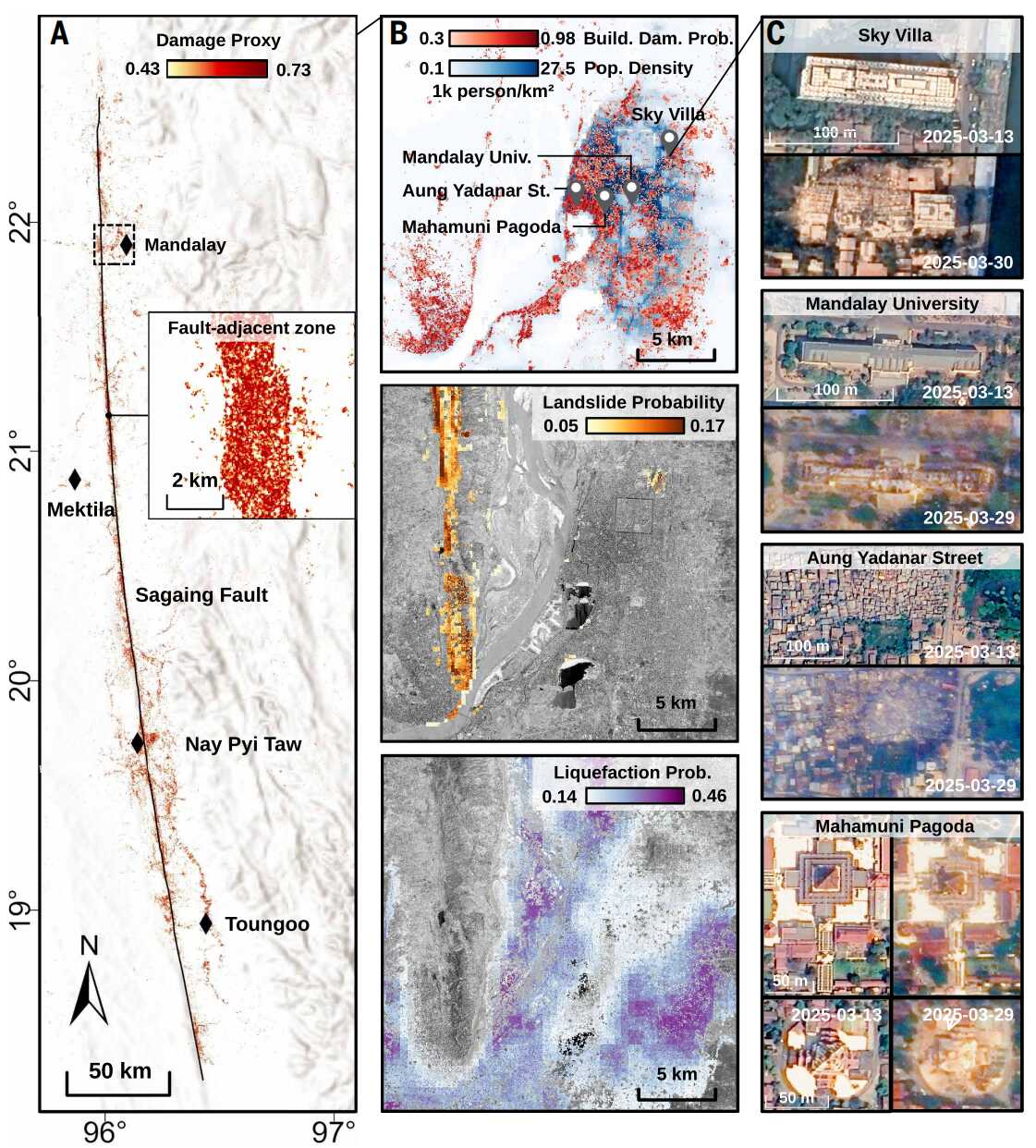
Multihazard analysis of the earthquake region along the Sagaing fault. (Image by AIRCAS)
"In regions where field investigations are extremely challenging, satellite remote sensing provides a unique and indispensable way to directly observe earthquake deformation and damage," said Professor ZHANG Yunjun. "By integrating multi-source SAR data with seismic observations, we were able to reconstruct the rupture process with unprecedented detail."
The first author of the study is XU Liuwei, a Ph.D. student at UCLA, the corresponding author is Professor MENG Lingsen of UCLA. The research team also includes Professor ZHANG Yunjun, Ph.D. students YANG Yanchen, WANG Yidi, and master student HU Changyang from AIRCAS; Professor WENG Huihui from Nanjing University; Professor XU Wenbin from Central South University; Elizabeth Su from UCLA; and Professor JI Chen from the University of California, Santa Barbara.
This study follows eartlier work by Professor ZHANG Yunjun and collaborators who in 2024 published another Science cover article on the rupture mechanism of the 2024 Noto peninsula, Japan earthquake. Together, these studies underscore the growing role of satellite remote sensing in advancing earthquake science and strengthening disaster risk assessment in regions where conventional observations are limited.

Cover of Science, August 23, 2024. (Image courtesy of Science)
News & Events