Global 30-m Urban Boundary Map Released, Offering 23 Years of City Expansion Insights
A research team led by Prof. LIU Liangyun from the Aerospace Information Research Institute of the Chinese Academy of Sciences (AIRCAS) has produced the first comprehensive, high-resolution map of global city and town boundaries, providing an unprecedented view of how urban boundaries have expanded and transformed over the past two decades. The new dataset—derived from 30-meter-resolution observations—fills a long-standing gap in global urban studies and provides planners and scientists with a powerful tool for examining sustainable development challenges.
Cities and towns are regarded as the dominant form of human settlements, crucial for maintaining ecological balance and sustainable development. However, their complex spatial structure and rapid evolution have made high-resolution global urban boundary datasets scarce. To address this, the team combined the GISD30 global impervious surface dynamic dataset with the LandScan global population data to create the ' (GCTB) Dataset spanning from 2000 to 2022.
The study, published in Scientific Data, details how the researchers developed a morphology-oriented boundary delineation framework that integrates kernel density estimation (KDE) and cellular automata (CA) urban boundary accurately. When compared with multiple reference datasets, GCTB showed the best agreement with the manually curated Atlas of Urban Expansion, achieving R² values about 0.88, indicating high reliability in capturing urban extents.
Independent validation based on OpenStreetMap (OSM) place tags for three benchmark years 2015, 2020, and 2022 further indicates the dataset's robustness. GCTB achieved an average overall accuracy of about 0.75, with mean precisions of ~0.78 for cities and ~0.69 for towns, further demonstrating consistent performance across time and settlement types.
To illustrate the dataset's capabilities, the researchers analyzed long-term urban changes of Beijing and Chicago using historical high-resolution Google Earth imagery. The results show the accurate spatial evolution of GCTB City and Town boundaries. GCTB effectively traced the contrasting urban expansion patterns of each metropolitan area— capturing Beijing's rapid outward expansion and Chicago's shift towards a more stable urban structure between 2000, 2010, and 2020.
The full dataset is openly accessible at the Zenodo platform, offering global policymakers, scientists, and planners with detailed, consistent insights into the spatiotemporal evolution of cities and towns over the past 23 years. As cities continue to grow and reshape landscapes worldwide, the GCTB dataset offers an essential spatial evidence for monitoring urban expansion, guiding land-use planning, and advancing sustaiable urban development.
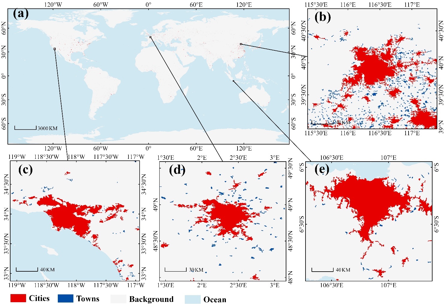
Global distribution of cities (red) and towns (blue) in 2022 at 30 m resolution (a), with insets for Beijing–Tianjin–Hebei (b), Los Angeles (c), Paris (d), and Jakarta (e). (Image by AIRCAS)
News & Events