High-Resolution Satellite Remote Sensing Reveals Underestimated Methane Emissions from Global Landfills
A research team led by Dr. CHENG Tianhai at the Aerospace Information Research Institute (AIR) of the Chinese Academy of Sciences has made significant progress in monitoring methane emissions from landfills. By leveraging high-resolution satellite remote sensing, the team developed a method for accurately quantifying methane emissions from landfills. This method was applied to conduct a comprehensive global assessment of landfill emissions. The findings were published in Nature Climate Change on July 28, 2025.
Landfills are the third-largest anthropogenic source of methane globally, accounting for approximately 18% of total human-caused methane emissions. Accurate monitoring of landfill methane emissions is therefore crucial. Traditional approaches—primarily based on ground-based measurements and modeling—are often constrained by sparse spatial coverage, insufficient accuracy, and the high cost of field observations.
In this study, the research team employed high-resolution satellite remote sensing with a spatial resolution of 30 meters and a spectral resolution of 10 nanometers. By combining a matched filter algorithm with an enhanced integrated mass method, they successfully identified and quantified methane plumes—distinctive, feather-like emission structures formed as methane disperses from emission sources—at 102 landfills worldwide. A total of 367 valid plumes were detected, enabling precise quantification of methane emission rates from landfills on a global scale.
"Satellite remote sensing allows for consistent, high-resolution quantification of landfill methane emissions on a global scale—something that traditional methods cannot achieve," said Dr. CHENG Tianhai, corresponding author of the study and a researcher at AIR. "Our approach significantly enhances both the accuracy and spatial coverage of landfill emission monitoring, offering a powerful new tool for global methane surveillance. It is expected to provide robust data support for shaping international methane mitigation policies."
The research examined two primary types of landfills worldwide: open dumpsites, which lack proper containment or control measures, and engineered sanitary landfills, which are designed and operated to safely manage municipal solid waste. To validate their satellite-based retrievals, the team compared the results with airborne measurements that had previously been verified through ground-based observations. The strong agreement between the datasets confirmed the reliability of the method.
The findings show that methane emissions from landfills are heavily influenced by waste management practices. On average, open dumpsites emit 4.8 times more methane than sanitary landfills. "This is the first study to systematically evaluate, on global scale, how different landfill management practices affect methane emissions," said TONG Haoran, first author of the study and a PhD candidate at AIR.
"We also found that the widely used Emissions Database for Global Atmospheric Research (EDGAR), developed by the European Union, substantially underestimates emissions from high-emitting open dumpsites—by a factor of about five, on average. Our work provides a scientific basis for correcting such biases in current emission inventories."
Building on these findings, the research team calls for strengthened international efforts to improve landfill infrastructure and waste management practices. They also advocate for the establishment of a global satellite data-sharing platform to ensure equitable access to critical emissions information—particularly for resource-limited countries—thereby supporting collective progress in mitigating global greenhouse gas emissions.
By integrating multi-source satellite data, the newly developed method for accurately quantifying methane emissions offers a viable technical pathway for large-scale, continuous monitoring of global landfill sites. This approach is expected to facilitate the development of methane emission databases under diverse climate conditions, significantly improve the accuracy of landfill gas emission models, and provide a robust observational foundation for developing high-resolution, time-resolved inventories of methane emissions from solid waste.
Peer reviewers praised the study for its scientific significance and practical potential, highlighting its novel perspective that enables clearer and more comprehensive data acquisition for landfill monitoring. The findings were recognized as "a potential breakthrough in remote sensing applications for solid waste management, demonstrating a high-tech, cross-disciplinary innovation." More importantly, the study is expected to catalyze a shift in landfill monitoring—from isolated, sporadic measurements to a large-scale, continuous system akin to modern weather forecasting.
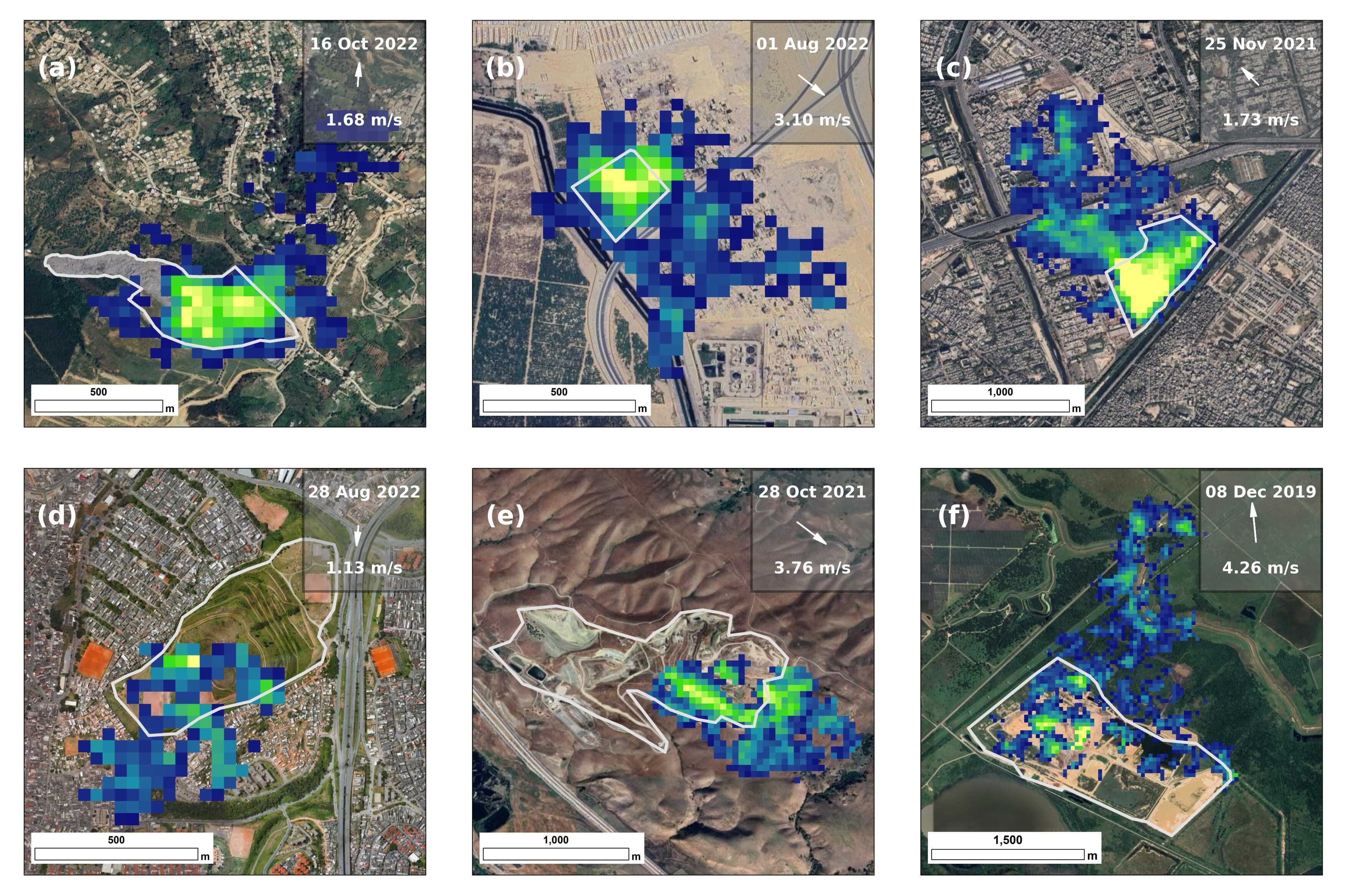
Satellite-based remote sensing detection of methane distribution at landfill sites. Panels a-c depict open dumpsites, while panels d-f show engineered sanitary landfills. (Image by AIR)
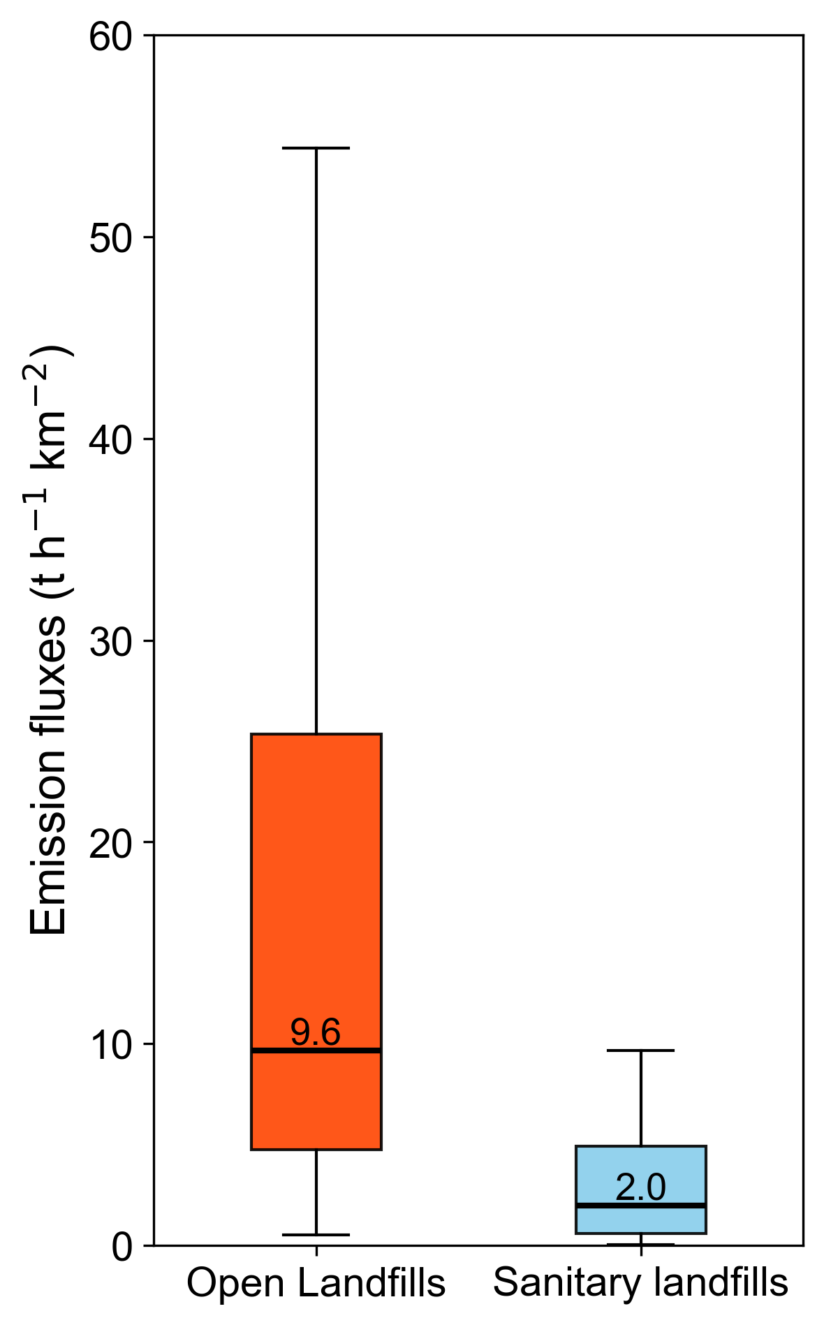
Methane emission flux distributions from two landfill types: open dumpsites and sanitary landfills. (Image by AIR)
News & Events