Chinese Researchers Revolutionize Satellite Data Processing with New 4D Format and MARS Software
Researchers at the Chinese Academy of Sciences' Aerospace Information Research Institute (AIR) have unveiled a groundbreaking Multi-Dimensional Data (MDD) format and MARS software that unifies time, space, and spectral dimensions of satellite data for the first time. Published in The Innovation and led by Professor ZHANG Lifu, this innovation processes Earth observation data 482% faster than industry-standard ENVI software while using 97% less storage—solving decades of fragmentation in environmental monitoring.
The MDD format integrates data into four-dimensional framework (time+space+spectrum) through five adaptive storage structures, including Temporal Sequential in Band (TSB), Temporal Sequential in Pixel (TSP), Temporal Interleaved by Band (TIB), Temporal Interleaved by Pixel (TIP) and Temporal Interleaved by Spectrum (TIS). TSB/TIB is suitable for precision agriculture like crop phenological tracking, TIP/TSP for deforestation and disaster monitoring, and TIS for 3D environmental visualization. Paired with freely available MARS software, MDD processes Landsat and MODIS satellite data in 187 seconds—5.8 times faster than ENVI's 1,089 seconds for equivalent tasks.
Real-world applications demonstrate transformative efficiency: a global soil moisture dataset (2003–2018) collapsed from 576 files to just 16 MDD files, while East Lake water quality analysis now takes hours instead of weeks. The MDD format can accelerate preprocessing for advanced AI-models like DeepSeek and ChatGPT, enabling faster large-scale environmental predictions. Currently operational at China’s National Earth Observation Data Center and certified as a CAGIS (the China Association for Geographic Information Systems) industry standard, MDD supports applications from climate modeling to flood monitoring.
Global experts hail the breakthrough—Professor LI Deren (CAS/CAE) praises its dual theory-technology innovation, while Professor Antonio J. Plaza calls it a world-class advancement. Future integration with platforms like Google Earth Engine could enable real-time global change tracking.
Developed over 13 years with support from China's National Key R&D Program, this milestone addresses urgent climate and food security challenges. As Prof. Zhang notes, MDD and MARS provide the integrated toolkit we need to monitor our rapidly changing planet.
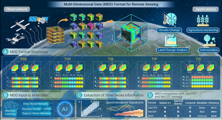
The multi-dimensional remote sensing data format. (Image by AIR)
News & Events