Chinese FY-3 Satellites Enrich Global Soil Moisture Dataset
Apr 04, 2023
Surface soil moisture (SSM) plays an important role in drought and flood monitoring, weather forecasting, among other natural resource activities, and is also critical in water and heat exchanges between land and atmosphere.
SSM can be measured by instruments in the field or by remote sensing techniques. Satellite observations from active and passive microwave sensors are best suited for the retrieval of soil moisture at global scale.
A study entitled "A global daily soil moisture dataset derived from Chinese FengYun-3B Microwave Radiation Imager (MWRI) (2010-2019)" was published on Scientific Data. The relevant dataset is available online at the National Tibetan Plateau Data Center.
Dr. YAO Panpan and Dr. ZHAO Tianjie from the State Key Laboratory of Remote Sensing Science with the Aerospace Information Research Institute (AIR), Chinese Academy of Sciences (CAS) and Dr. LU Hui from Tsinghua University developed this new FY-3B global SSM product from 2010 to 2019, with a spatial resolution of 36 km.
FengYun-3, or FY-3, are China's second-generation meteorological satellite series, which have provided sustainable and daily multiple observations from X-band since 2008.
However, SSM products from L-band observations, such as the Soil Moisture Active Passive (SMAP) Mission, have proven to be optimal global estimations. Compared to the L-band, the sensitivity of the X-band to soil moisture has decreased, and the accuracy of soil moisture products from the FY-3 series needs to be improved.
The research team transferred high accuracy of SMAP L-band to FY-3B X-band, combined microwave radiation transmission models with machine learning methods.
The validation results from 14 dense ground observation networks and 258 flux stations worldwide show this dataset is consistent with ground observations and SMAP products, with higher accuracy than the official soil moisture products of FY satellites.
They also released AMSR-E/AMSR2 soil moisture products (2002-2022). Because of its comparable accuracy and longer time series compared to SMAP, this dataset has received widespread attention and application. This dataset has a high consistency with AMSR-E/AMSR2, so it can fill the 9-month data gap of the AMSR series from 2011.10-2012.6.
With this new dataset and its continuous updates, Chinese FY-3 satellites may play a larger role and provide opportunities of sustainable and longer-term soil moisture data record for hydrological study.
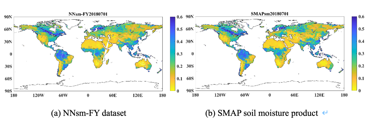
Global map of soil moisture on July 1, 2018 (average of 3-day data). (Image by AIR)
Contact: luyq@aircas.ac.cn
News & Events