AIR Scientists Conduct Experiments on Monitoring Grassland and Livestock Resources in China
Grasslands provide the cheapest feed resource for livestock industry, however, there are complex interactions between the grassland productivity and the numbers of livestock. As a result, a balance between a maximum level of grazing intensity and the optimized grassland capacity is required. Remote sensing provides a robust tool to mapping, monitoring, and management of the grasslands as well as herds on large scales.
A series of integrated experiments involving unmanned aerial vehicle (UAV), tethered balloon, satellites and in-situ observation were conducted at the Shertala and Hadatu Farms in Hulunbuir Prairie of northern China's Inner Mongolia from June 21 to July 23 to collect remote sensing data and in-situ data,which were used to provide strong data support for grasslands and livestock management and monitoring.
The experiments were conducted by the Key Laboratory of Quantitative Remote Sensing Information Technology as well as the Aerostat System Research and the Development Center with the Aerospace Information Research Institute (AIR) under the Chinese Academy of Sciences (CAS).
UAV-based experiments were carried out to monitor the grasslands and livestock in Shertala Farm. Scientists used the optical camera onboard the UAV to collect images of livestock such as cattle, sheep, and horses, which provided validation data for identifying livestock types and numbers. In addition, a red-edge multispectral camera, and a hyperspectral imager onboard the UAV were used to obtain the multi-source remote sensing data for natural grasslands and human-generated grasslands. Meanwhile, field measurements of ground-based Lidar, canopy spectral reflectance and biochemical parameters of human generated grassland (e.g. chlorophyll and leaf area index) were also conducted.
The airborne images as well as ground-based data will be used for the remotely sensed data validation, classification and identification of natural grassland grass species and growing status monitoring of human-generated grasslands.
A synchronous multi-platform observation experiment on the herds were conducted in Hadatu Farm.
The tethered balloon platform equipping with high-resolution visible light and infrared cameras, completed three balloon lifting tests with an altitude of 300 meters, which succeeded in realizing the continuous and dynamic monitoring of livestock behaviors within 30 square kilometers in the span of 12 hours across day and night. During the period, seven sub-meter satellite images over the region were obtained too, covering an area of more than 2,000 square kilometers. The UAV platform acquired centimeter-level ground verification data over 50 square kilometers.
By synchronously obtaining the multi-platform information of livestock, an accounting model will be developed, which will make it possible to count the number of different types of livestock accurately over this Farm and provide important data to support the study of grazing intensity and grassland management.
This experiment was supported by the Strategic Priority Research Program of CAS project "Accurate Evaluation of Grassland Resources and Grazing Intensity in Typical Pastoral Areas". Scientists carried out demonstration experiments in Hulunbuir, Inner Mongolia, with the purpose to evaluate and predict the annual changes of grassland resources in pastoral areas, accurately calculate the actual livestock carrying capacity, analyze the dynamic impact of carrying capacity and grazing on the growth process of different types of grasslands in typical pastoral areas, and produce an electronic atlas of demonstration areas.
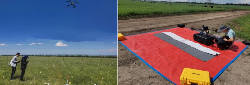
A UAV-based experiment is carried out to monitor the grasslands and livestock.
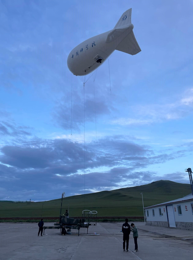
A tethered balloon-based experiment for livestock monitoring is prepared.
News & Events