Datasets Unveil Impacts of Land Use and Cover Change on Sahel in Africa
The Sahel-Sudano-Guinean region has been experiencing significant land cover and land use (LULC) change (LUCC) in the last decades due to climatic and anthropic impacts. The driving mechanism and eco-environmental effect of LUCC in the region is one of the hot issues in global change research, while a better understanding of these changes is essential for sustainable land and water management in the region.
Four datasets on the Sahel-Sudano-Guinean region of Africa have been recently released on the platform of the National Tibetan Plateau / Third Pole Environment Data Center. The four datasets include: 1) 30m resolution land use/cover the (1990-2020); 2) annual NPP-VIIRS (National Polar-Orbiting Partnership - Visible Infrared Imaging Radiometer Suite) night time light (2013-2020); 3) long time series on night time light on the same region as data set (2), but a much longer period of time (1992-2020); 4) inventory and extent of surface water bodies (2000-2020).
The datasets are based on the project "Driving Mechanisms and Impacts of Land Use and Cover Change in the Sahel: Responses and Impacts" which was jointly supported by the National Natural Science Foundation of China (NSFC) International Cooperation and Exchange Program and the United Nations Environment Program (UNEP). The NSFC-UNEP project is led by Prof. JIA Li from State Key Laboratory of Remote Sensing Science, Aerospace Information Research Institute (AIR), Chinese Academy of Sciences (CAS).
The land use/cover dataset on the Sahel-Sudano-Guinean region in Africa (1990-2020) is a 30m LULC classification product generated every five years from 1990 to 2020 and covers the region between 0° and 30°N in Africa (Figure 1). The overall accuracy of the dataset is about 75%, and the accuracy of change detection is higher than 70%. The LULC data are in good agreement with the FAO statistical data and delineate similar spatial pattern as other existing land cover maps. The dataset provides information to support sustainable use of land resources and environmental protection in the Sahel Sudano - Guinean region of Africa.

Figure 1. The multiannual 30m resolution land use and cover maps of the Sahel-Sudano-Guinean region in Africa every five years in 1990-2020). (Credit: AIR)
The data on NPP-VIIRS annual nighttime light, covering the region between 0° and 20°N in Africa, achieved better quality in the Sahel-Sudano-Guinean region (2013-2020) than the initial NPP-VIIRS monthly average night light data by developing and applying the Patch Filtering Method (PFM), which can effectively distinguish urban stable nighttime light from unstable night time light caused by biomass burning and capture better information on urban areas. To a certain extent, the dataset improves the ability to identify small-scale, scattered, and unstable urban lights in the Sahel-Sudano-Guinean region, and can be further applied to explore human activities.

Figure 2. Example of annual NPP-VIIRS night time light map in the Sahel-Sudano-Guinean region (2016). (Credit: AIR)
In general, the intensity and spatial distribution of night time light obtained by satellite remote sensing provide useful information for the study of human activities. In the Sahel-Sudano-Guinean region, however, the study on spatio-temporal patterns and changes of human activities over a longer period of time is hindered by the lack of high quality, long-time series on night time light data. A median calibration method was developed to construct a long-term night time light dataset from 1992 to 2020 in this region by integrating and inter-calibrating the DMSP-OLS (Defense Meteorological Satellite Program - Operational Linescan System) night time light data (in digital number values) and NPP-VIIRS night time light data (in radiance) (Figure 3). This dataset can be used to analyze temporal and spatial changes in human activities in the region.
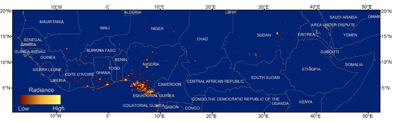
Figure 3. Example of the long time series on night time light in the Sahel-Sudano-Guinean region (2013). (Credit: AIR)
The dataset on the surface water bodies in the Sahel-Sudano-Guinean region includes the extent and area of surface water bodies larger than 1 km2 in 23 countries during 2000-2020 (Figure 4). This dataset provides information upscaled from pixels to entire surface water bodies, which is of more practical significance in geospatial-analyses. The dataset is likely useful to support for surface water resources assessment and other studies in the region.
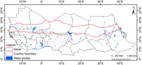
Figure 4. The maximum extent of surface water bodies between 2000-2020 in the Sahel-Sudano-Guinean region. (Credit: AIR)
News & Events