Global Forest Canopy Covers may be Underestimated, Study Finds
A research team led by the scientists from the State Key Laboratory of Remote Sensing Science under the Aerospace Information Research Institute (AIR), Chinese Academy of Sciences has found, in their study to estimate the forest canopy covers in northeastern China, the underestimation of about 20% of forest canopy covers may exist in three well-known global maps.
Canopy cover, the area of the ground covered by a vertical projection of the canopy, serves as a critical parameter for studies on forest ecosystems and potential carbon sinks, and the estimation of forest canopy cover has become an important part of forest inventories.
Satellite mapping, bolstered by algorithmic assessment, provides an indispensable view of Earth's canopy covering. The maps are typically assessed by visually reviewing the satellite images or by cross-examining overlapping views but are rarely confirmed via field observations due to the sheer size of coverage and difficult terrain. Now, with the advent of unmanned aerial vehicles (UAV) equipped with high-resolution cameras, researchers are getting a better look at the greenery and calling the maps' accuracy into question.
But it's not as simple as better visuals - cameras are limited to how they process spectral information, meaning the greens of a canopy and its understory may not be as nuanced when viewed directly by the human eye.
Several well-known global maps have been released in the last decade, but before they can be fully applied with confidence, they need to be independently assessed - which is a problem due to the unavailability of sufficient reference data.
To clear the bottleneck, the researchers designed BAMOS to combine the spectral information from a digital orthophoto map - a computer-generated image with a map's clean description of terrain details and the visual details of an aerial photo - with a digital surface model, which displays the environment's features from a top-down view.
Samples of canopy covers were produced by applying the BAMOS method on the UAV images collected at 77 sites across Daxing'anling forested area in the northeast of China. The results showed that the canopy cover extracted by the BAMOS was highly correlated to visually interpreted ones, with an error of about 5.7%.
The researchers used this information to assess the accuracy of three widely used global maps: Global Land Analysis and Discovery laboratory (GLAD) map, Global Land Cover Facility (GLCF) map, and MOD44B Version 6 Vegetation Continuous Fields (MODIS VCF) map.
"Systematic underestimations of about 20% were obviously noticed in all three global maps, although all three had good consistency when compared to one another," said NI Wenjian, a researcher from AIR, noting they only compared the northeast China region. "Our study indicates the need for independent assessments of other locations on these global maps.
While both GLAD and GLCF captured the dominate spatial patterns, GLAD tended to miss scattered trees and GLCF did not capture non-tree areas. Ni also explained that while temporal differences between when the BAMOS information was collected and when the maps were developed may contribute to some of the underestimation, but the data shows time isn't the primary contributor.
"The GLAD map was developed about eight years prior to the BAMOS data collection and shows quite a different spatial pattern, especially in forested regions approaching to non-forest areas," Ni said. "This may be related to the growth of young forests during the eight-year interval. Nevertheless, MODIS VCF still has obvious underestimations with our data, taken at the same time, indicating the temporal inconsistency in this study cannot be the main factor causing such discrepancies, and further assessments are needed."
They published their method and results on the “Journal of Remote Sensing” with the title of “Regional Sampling of Forest Canopy Covers Using UAV Visible Stereoscopic Imagery for Assessment of Satellite-Based Products in Northeast China”.

Performance of BAMOS on the extraction of tree crowns at typical sampling sites under complicated light conditions. (Image credit: AIR)
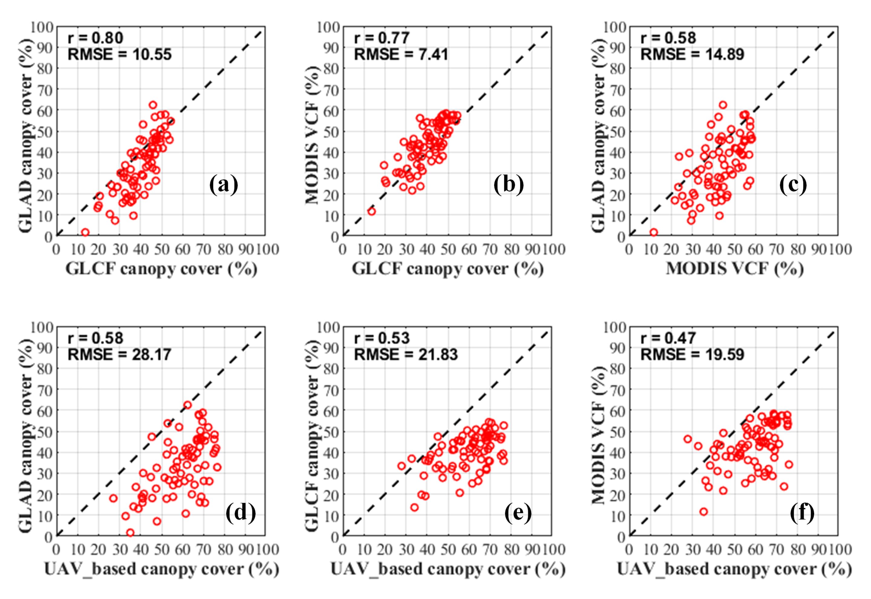
Assessment of three global maps at test sites (Image credit: AIR)
News & Events