Study Provides New Benchmark for Surface Radiation Product over East-Pacific Region
Prof. Husi Letu from the Aerospace Information Research Institute, Chinese Academy of Sciences, and his team on cloud remote sensing recently published a paper entitled "A new benchmark for surface radiation products over the East Asia-Pacific region retrieved from the Himawari-8" in the Bulletin of the American Meteorological Society (BAMS), a flagship journal of the American Meteorological Society.
This paper presents the characteristics and advancement of remote sensing products and algorithms for cloud properties and surface radiation developed by Husi Letu and his team over the years, proving that the accuracy of the new product is significantly superior to other similar products over the world.
The product is of great significance to improve the calculation accuracy of energy budget and reveal the mechanism of the interaction between cloud - radiation - climate change.
Surface downward radiation (SDR), including shortwave downward radiation and longwave downward radiation, plays an important role in energy and climate studies. It serves as an important parameter for calculating the surface radiation budget, as well as an important input parameter for land surface, hydrology, climate and other models.
With the continuous launch of high temporal-spatial resolution satellites and the continuous improvement of remote sensing inversion algorithms, the demand for high-precision surface radiation products turns out to be urgent.
For this purpose, Husi Letu and his co-authors from the National Space Science Center of Chinese Academy of Sciences, Sun Yat-sen University, Tokai University, and other research institutions have developed a new dataset from the new generation geostationary satellite Himawari-8: "East Asia-Pacific longwave/shortwave downward radiation at the surface data set (2016-2020)".
The generation of this dataset is based on the look-up table method (for shortwave radiation) and the general parameterization method (for longwave radiation). The main input data is the retrieved cloud properties including cloud optical thickness (Figure 1), cloud effective radius and cloud top temperature, combining with auxiliary data such as water vapor, surface temperature, and ozone derived from ERA5, the fifth-generation reanalysis global atmosphere dataset from the European Centre for Medium-Range Weather Forecasts.
This method takes full advantage of the high spatial-temporal resolution (10min/5km) and wide spatial coverage of the Himawari-8 satellite (80E-200E, 60S-60N), and the time span is 2016-2020. Figures 2 and 3 respectively show the validation results of shortwave and longwave radiation in this study, Clouds and Earth's Radiant Energy Systems (CERES) and ERA5 products.
It is concluded that, in general, the accuracy of the shortwave radiation estimated by the Himawari-8 satellite is significantly higher than that of CERES. The overall accuracy of longwave radiation is comparable to the ERA5 products, and it has evidently better performance over high-altitude areas with a high spatial resolution.
This research was jointly funded by the National Key Research and Development Program (2018YFA0605401), the National Natural Science Foundation of China (42025504, 42022008, 41771395) and the second comprehensive scientific expedition to the Qinghai-Tibet Plateau (2019QZKK0206).
Group photo of Dr. Husi Letu's team. (Image by AIR)
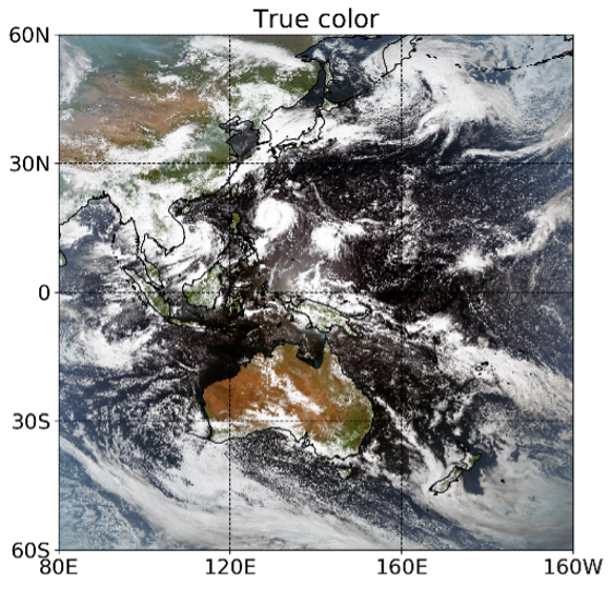
Figure 1. (left) True color image from Himawari-8, (right) retrieved cloud optical thickness (0300 UTC on September 12, 2016). (Image by AIR)
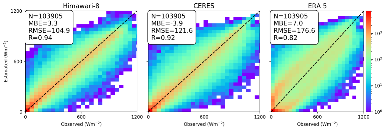
Figure 2. Comparison of the hourly SWDR results of H-8, CERES and ERA5 to ground-based measurements in 2016. MBE and RMSE are expressed in Wm-2. The number of ground sites is 27. (Image by AIR)
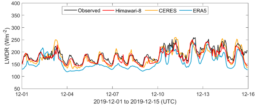
Figure 3. Comparison of the diurnal variations in LWDR among CERES (1 h), ERA5 (1 h), H-8 (10 min) and ground-based measurements (10 min) from August 21-25, 2016. The zero-value dots during the nighttime denote invalid data. (Image by AIR)
Dataset download: https://doi.org/10.11888/Meteoro.tpdc.271729.
News & Events