CAS Releases Global 30-m Impervious Surface Map
According to the Aerospace Information Research Institute (AIR), Chinese Academy of Sciences (CAS), a research team led by Prof. LIU Liangyun has released global 30-m impervious surface datasets with an accuracy of 95.1 %, the highest accuracy among existing data products of this kind. The related paper has been published in the journal Earth System Science Data, with the title of “Development of a global 30-m impervious surface map using multi-source and multi-temporal remote sensing datasets with the Google Earth Engine platform”.
Impervious surfaces are usually covered by anthropogenic materials like sand and stone, concrete, bricks, and glass to prevent water penetrating into the soil. Along with the increase of human activity is the rapid growth of the impervious surfaces, leading to emerging climate, environmental and even social problems such as urban heat islands, traffic congestion, and deteriorating urban environment. Consequently, the impervious surface has become an important indicator in the monitoring of the intensity of human activity and environmental change.
The remote sensing technology is considered to a good means for mapping impervious surfaces covering large areas, while the accuracy on the global scale is still face great challenges largely due to the complex spectral and spatial characteristics of impervious landscapes, and this is why the traditional spectral index-based mapping methods, which use single optical or radar data source, suffer relatively heavy omission errors.
In this study, scientists generated an accurate global impervious surface map at a resolution of 30-m for 2015 by combining Landsat 8 Operational Land Image (OLI) optical images, Sentinel-1 SAR images and Visible Infrared Imaging Radiometer Suite (VIIRS) NTL images based on the Google Earth Engine (GEE) platform.
First, the global impervious and non-impervious training samples were automatically derived by combining the GlobeLand30 land-cover product with VIIRS NTL and MODIS enhanced vegetation index (EVI) imagery.
Then, the local adaptive random forest classifiers, allowing for a regional adjustment of the classification parameters, were trained and used to generate regional impervious surface maps for each 5°×5° geographical grid using local training samples and multisource and multi-temporal imagery.
Finally, a global impervious surface map (MSMT_IS30-2015), produced by mosaicking numerous 5°×5° regional maps, was validated by interpretation samples and then compared with five existing impervious products (GlobeLand30, FROM-GLC, NUACI, HBASE and GHSL).
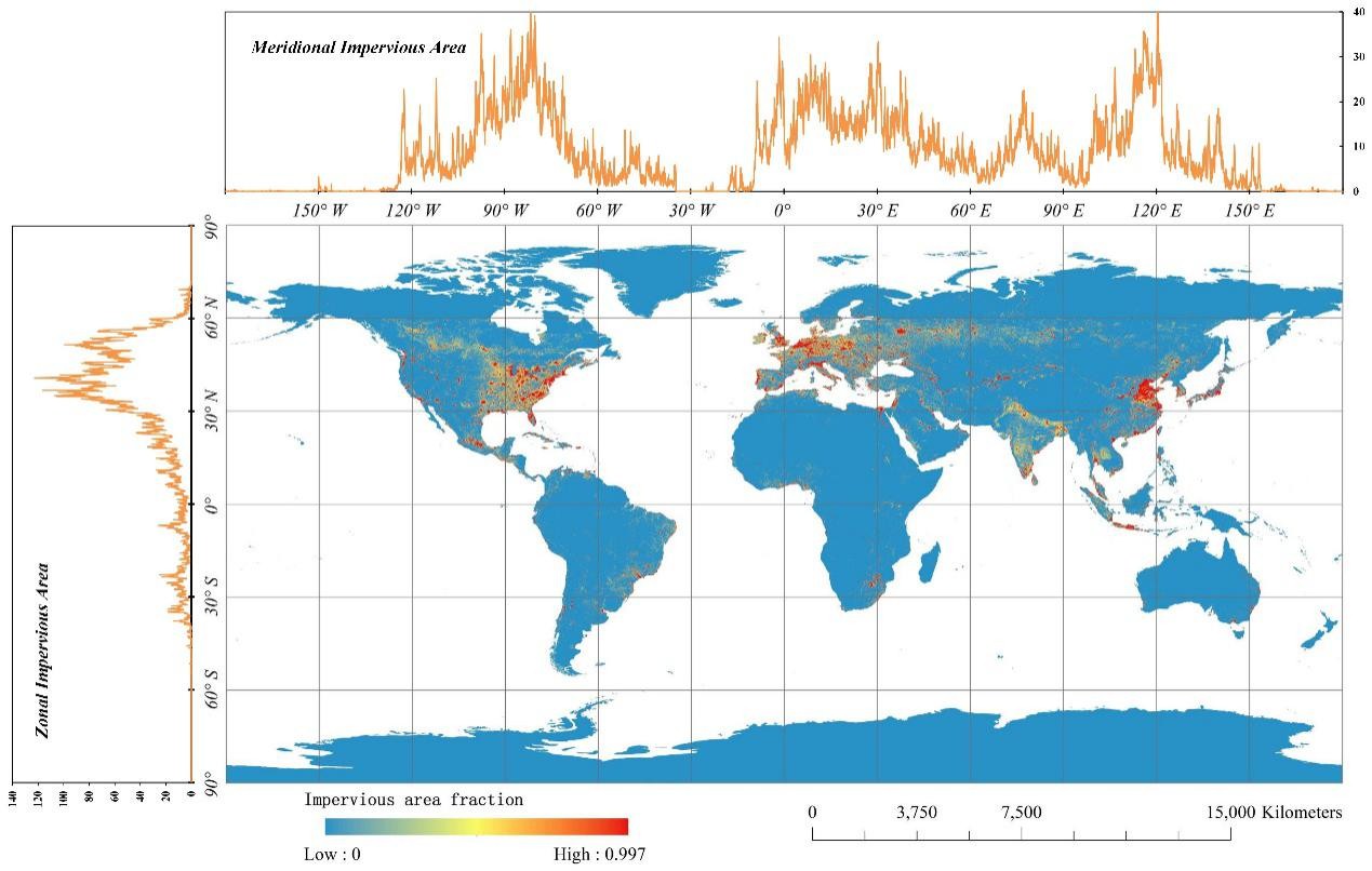
Figure 1. Global fraction of impervious cover derived from multisource and multitemporal Landsat 8 SR and Sentinel-1 SAR imagery acquired from 2015 to 2016. The spatial resolution of the map is 0.05°.
The global 30 m impervious surface product was validated and compared with five existing impervious surface products (GlobeLand30, FROM_GLC, NUACI, GHSL, and HBASE). The results indicated that this global impervious surface map produced using the multisource, multitemporal random forest classification (MSMT_RF) method was most accurate, with an overall accuracy of 95.1 % and kappa coefficient of 0.898, as against 85.6 % and0.695 for NUACI, 89.6 % and 0.780 for FROM-GLC, 90.3 % and 0.794 for GHSL, 88.4 % and 0.753 for GlobeLand30, and 88.0 % and 0.745 for HBASE.
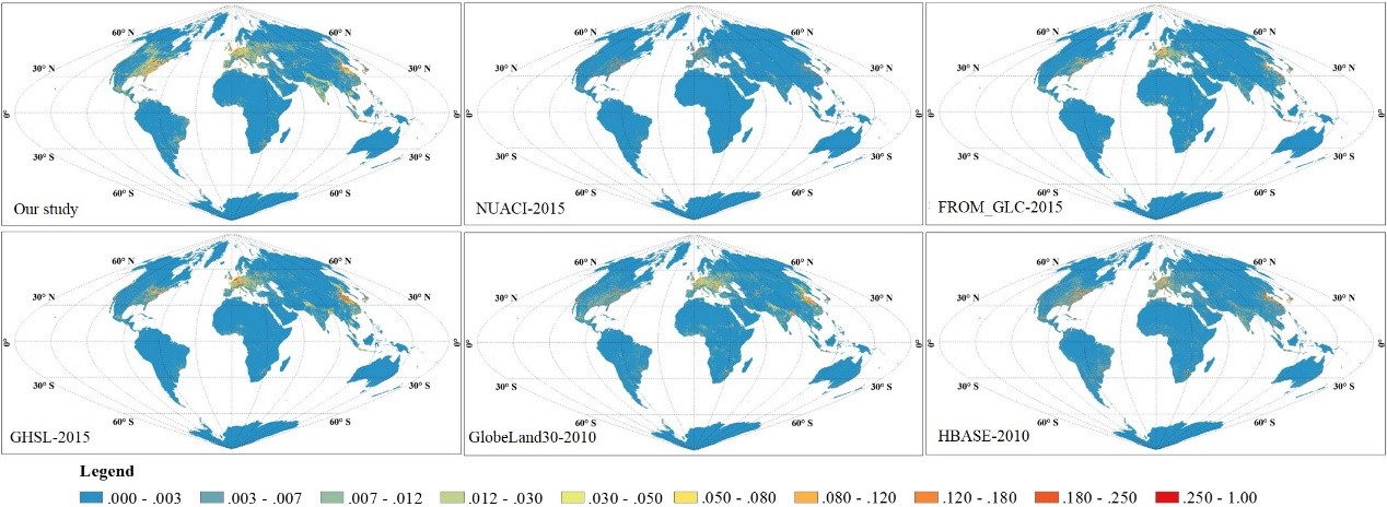
Figure 2. The spatial patterns of six global 30 m impervious products after aggregating to the resolution of 0.05°.
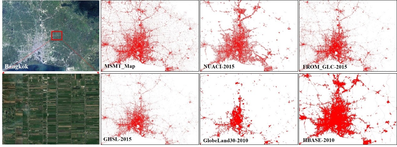
Figure 3. Comparisons between the MSMT_RF-based impervious surface maps and other products (corresponding to the NUACI products, the FROM-GLC products, the GHSL products, the GlobeLand30 products and the HBASE products respectively).
This research is supported by the Key Research Program of the Chinese Academy of Sciences (grant no. ZDRW-ZS-2019-1), the National Natural Science Foundation of China (grant no. 41825002) and the Strategic Priority Research Program of the Chinese Academy of Sciences (grant no.XDA19080304).
Paper and dataset information was listed as bellow.
Zhang, X., Liu, L., Wu, C., Chen, X., Gao, Y., Xie, S., & Zhang, B. (2020). Development of a global 30 m impervious surface map using multisource and multitemporal remote sensing datasets with the Google Earth Engine platform. Earth System Science Data, 12(3), 1625-1648. Paper Available at: https://essd.copernicus.org/articles/12/1625/2020/essd-12-1625-2020.html
The global impervious surface map dataset (MSMT_IS30-2015) is available at Zenodo: https://doi.org/10.5281/zenodo.3505079
News & Events