China’s Satellite Imagery Support Iran’s Flood Disaster Response
Record rainfall and floods hit large parts of Iran since mid-March 2019, causing many casualties and huge property loss. Responding to requests from UNESCAP and the Iranian Earthquake Engineering Association (IEEA), China GEO activated its Disaster Data Response (CDDR) Mechanism to provide high-resolution satellite imagery in support of disaster response planning.
The Aerospace Information Research Institute (AIR) under the Chinese Academy of Sciences (CAS) is responsible for the international data campaign based on the ChinaGEOSS Data sharing Network (ChinaGEOSS DSNet). Following the activation of the CDDR, AIR immediately set to collaborate with domestic satellite agencies, collect high-resolution satellite data on the flooded areas in Aq Qala, Darvazeh Quran and Pol Dokhtar, and organize related data analysis.
During the week after the CDDR for Iran, China GEO has acquired more than 20 GB before and after high-resolution images on the flood affected areas provided by seven Chinese satellites including Gaofen-1, Gaofen-2, ZY-3 and JiLin-1. The weather information for the disaster areas is provided by the National Satellite Meteorological Center (NSMC) to help satellite agencies develop timely and effective satellite observation plans.
The data has been provided to Iran's National Disaster Management Organization (NDMO) and Iranian Red Crescent as the key disaster management operational bodies, helping them make flood analysis, damage assessment, and plan their response operations.
The data sharing service on the “Disaster Data Response for Iran Flood 2019” is accessible via internet, by which all of the data and disaster information are full and open to scientists and disaster reduction agencies around the world. As of April 10, the number of over 110GB data is downloaded by the users mainly came from Japan, Iran, the United States, Italy, etc.
The data is also provided to international agencies such as the Group on Earth Observation (GEO), the Committee on Data for Science and Technology (CODATA), the Integrated Research on Disaster Reduction (IRDR), among others.
The data assistance campaign for Iran showcases China’s development in Earth observation, which enables China to provide timely and reliable satellite data for international disaster relief.
Established in 2016, the China GEOSS Disaster Data Response Mechanism is responsible for coordinating the provision of Chinese high-resolution satellite data and disaster analysis products to disaster-affected countries. The mechanism has been successfully launched for earthquakes, floods, tsunamis and typhoons in fourteen countries.
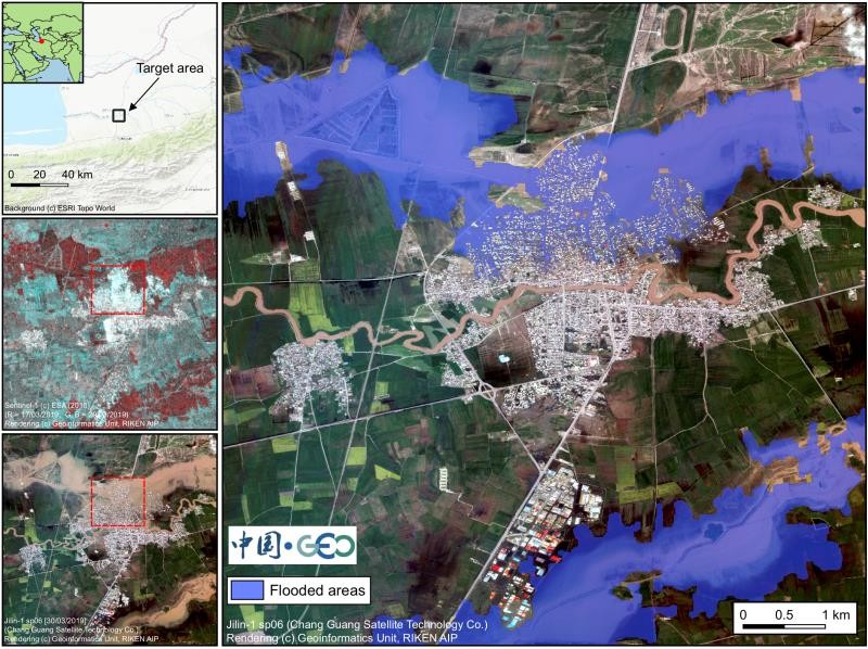
Thematic map of 2019 Iran flooded areas (data source: JiLin-1).
News & Events