-
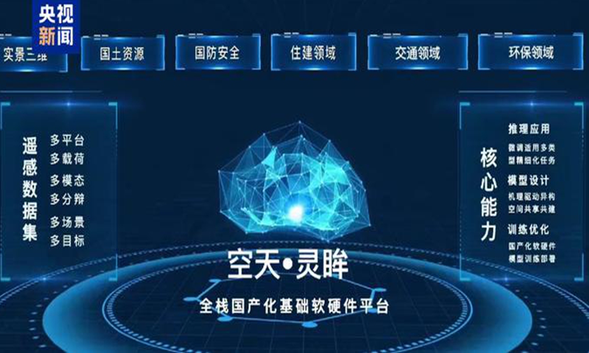
China Launches World's First 10b Parameter Remote Sensing Basic Model
The world's first large-scale remote sensing basic model with more than 10 billion parameters, "RingMo 3.0," was launched at the first Aerospace Information Technology Conference on Saturday, marking it as an integrated space-air remote sensing model.
Sep 23, 2024
-
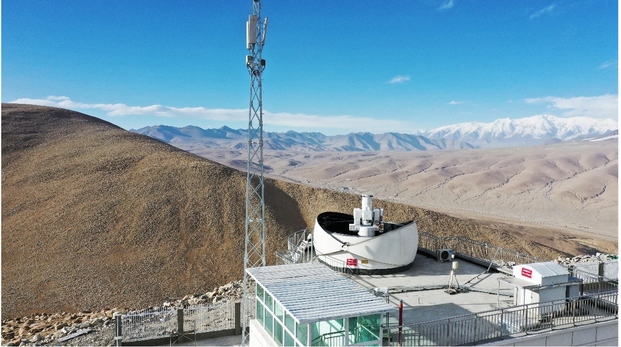
China Focus: China Builds Laser Communication Ground Station for Massive Satellite Data Transmission
URUMQI, Sept. 15 (Xinhua) -- A laser communication ground system with a 500mm-caliber antenna was successfully deployed Sunday on the Pamir Plateau in northwest China's Xinjiang Uygur Autonomous Region, which is expected to significantly enhance the country's capacity for massive satellite data transmission.
Sep 17, 2024

-
China Focus: China's Homegrown Remote Sensing Aircraft Elevates Scientific Exploration
XI'AN, Sept. 11 (Xinhua) -- China's homegrown MA60 remote sensing aircraft has enabled scientists to conduct scientific studies via a large aerial platform. The aircraft has filled the country's blank in terms of large and medium-sized remote sensing aircraft featuring long range, multi-tasking ability, multi-function capability and multi-watch windows, according to the Aviation Industry Corporation of China (AVIC), the country's leading aircraft manufacturer.
Sep 11, 2024

-
Beijing Declaration Released at FBAS 2024 to Accelerate Sustainable Development via Digital Tech
The Fourth International Forum on Big Data for Sustainable Development Goals (FBAS 2024) concluded on September 8 in Beijing, marking a significant leap in global efforts to achieve the Sustainable Development Goals (SDGs). More than 800 representatives from United Nations agencies, research institutions, and universities around the world convened to explore the potential of digital technologies in accelerating sustainable development. The event culminated in the release of the “Beijing Declaration on Partnership for Accelerating Sustainable Development through Digital Technologies.”
Sep 09, 2024
-
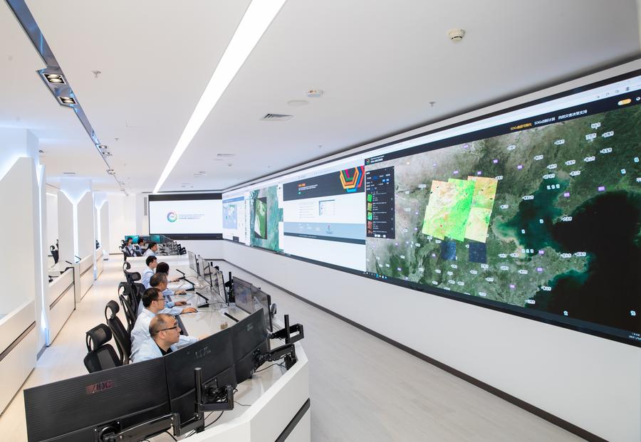
World's First Atlas of Remote-sensing Thermal Infrared Images Released in Beijing
Researchers work at the International Research Center of Big Data for Sustainable Development Goals (SDGs) in Beijing, capital of China, Sept. 8, 2021. (Xinhua/Jin Liwang) BEIJING, Sept. 7 (Xinhua) -- The International Research Center of Big Data for Sustainable Development Goals (CBAS), which is based in Beijing, on Friday released the world's first atlas of remote-sensing thermal infrared images, providing valuable data support for sustainable development research.
Sep 08, 2024
-
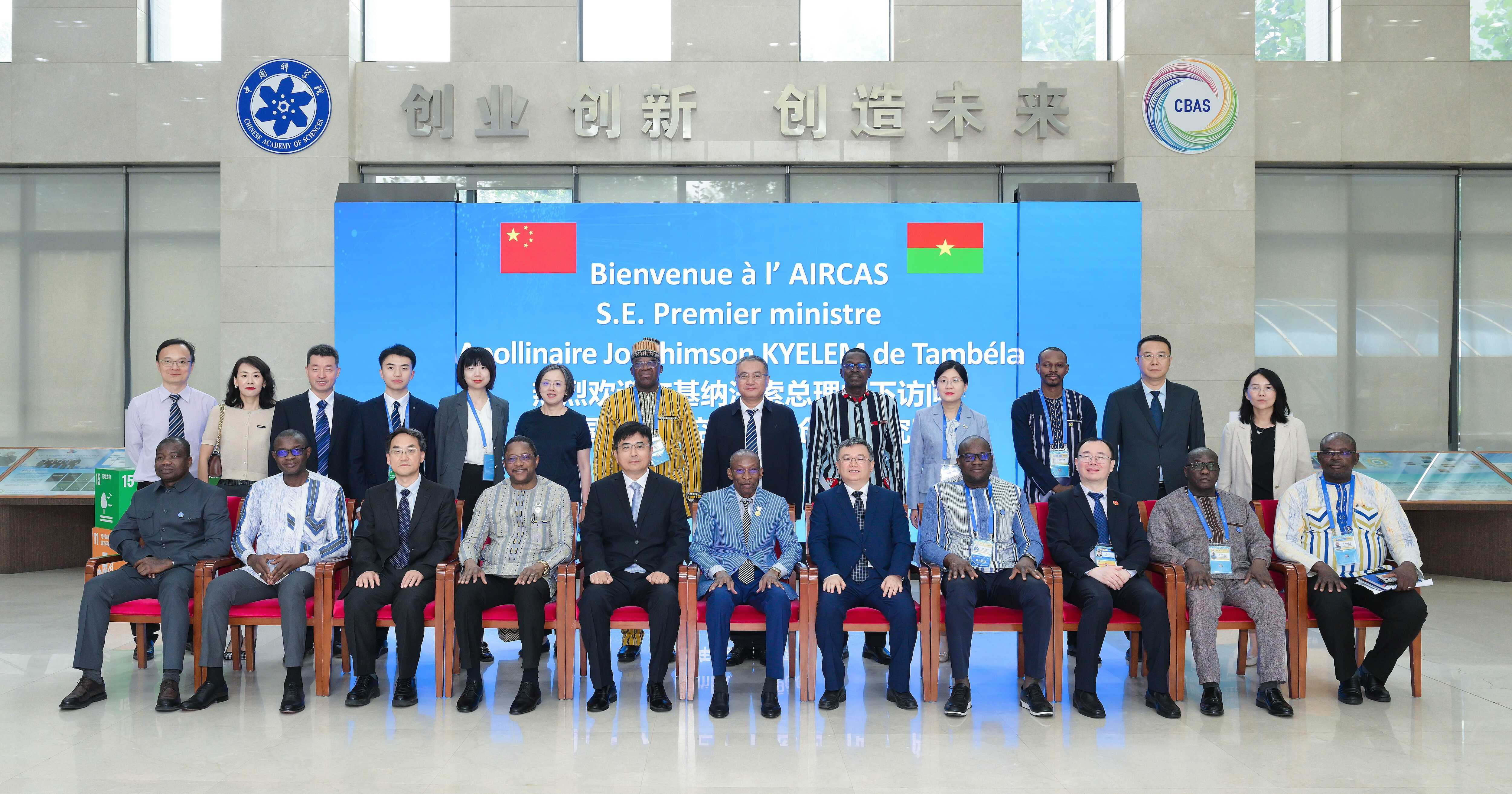
Burkina Faso's Prime Minister Visits Aerospace Information Research Institute
Burkina Faso's Prime Minister Apollinaire Joachimson Kyelem de Tambela visited the Aerospace Information Research Institute (AIR) under the Chinese Academy of Sciences (CAS) on the afternoon of September 4, during his trip to China for the 2024 Summit of the Forum on China-Africa
Sep 05, 2024
-
Across China: China initiates microwave remote sensing experiments for vegetation, soil moisture
SHIJIAZHUANG, Aug. 7 (Xinhua) -- Chinese researchers have recently initiated remote sensing experiments for vegetation and soil moisture in north China's Hebei Province, according to the Aerospace Information Research Institute (AIR) under the Chinese Academy of Sciences.
Aug 08, 2024

-
CropWatch-ICP Regional Center Launched to Enhance Agricultural Resilience in West Africa
From July 2 to 5, the United Nations Commission on Science and Technology for Development (UNCSTD), the Aerospace Information Research Institute (AIR) of the Chinese Academy of Sciences (CAS), the Alliance of National and International Science Organizations for the Belt and Road Regions (ANSO), and the National Space Research and Development Agency of Nigeria (NASRDA) jointly hosted a landmark workshop on advanced crop condition remote sensing monitoring. The event, aimed to enhance agricultural resilience and food security in Nigeria and West Africa, witnessed the inauguration of the first overseas center under the CropWatch Innovation Cooperation Program (CropWatch-ICP) in the region.
Jul 19, 2024
-
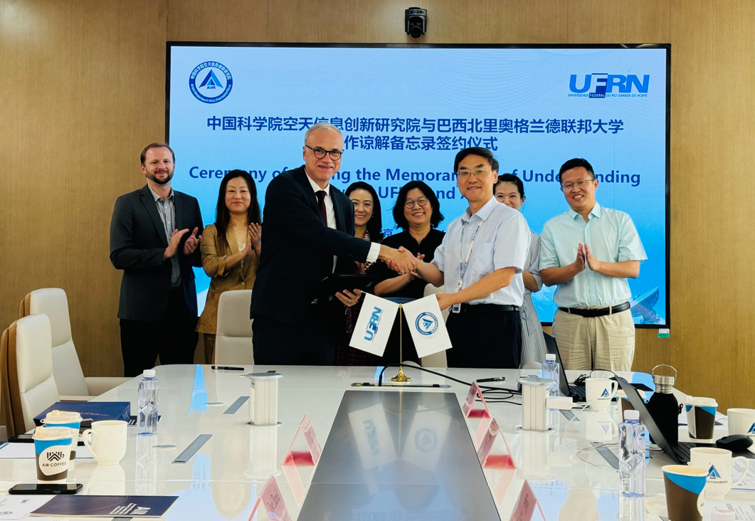
AIR, UFRN Sign MOU to Collaborate on Earth Observations
On July 8, 2024, the Aerospace Information Research Institute (AIR), Chinese Academy of Sciences (CAS) signed a memorandum of understanding (MOU) in Beijing with the Federal University of Rio Grande Do Norte (UFRN) of Brazil to boost further collaboration.
Jul 17, 2024

-
AIR Sponsored Journals Achieve Top Rankings in Latest JCR Report
On June 20, 2024,Clarivate Analytics released the latest Journal Citation Reports (JCR), revealing significant achievements for the Aerospace Information Research Institute (AIR) of the Chinese Academy of Sciences. All five English-language academic journals sponsored by AIR have entered the Q1 category in their respective international disciplines, establishing a leading cluster of scientific journals in the global aerospace information field.
Jun 28, 2024
-
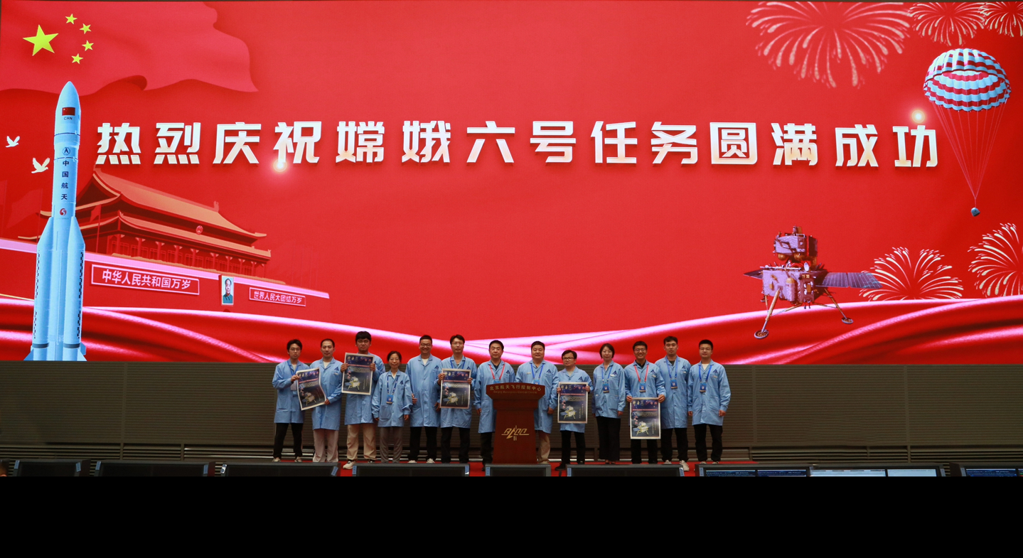
Int’l Payload Laser Retroreflector Deployed on Moon's Far Side by Chang’e-6 Mission
Among the international payloads onboard is the laser retroreflector INRRI (INstrument for landing-Roving laser Retroreflector Investigations), a joint development by the National Laboratory of Frascati, National Institute for Nuclear Physics (INFN-LNF) and the Planetary Mapping and Remote Sensing Laboratory from the Aerospace Information Research Institute (AIR), Chinese Academy of Sciences (CAS). Mounted on the top panel of the Chang’e-6 lander, and successfully deployed on the far side of the moon, INRRI, which functions as a mirror for laser beams, aims to be the first laser retroreflector absolute control point on the moon’s far side. It will provide support for high-precision positioning on the lunar surface and the orbit determination and navigation of lunar orbiters.
Jun 25, 2024
-
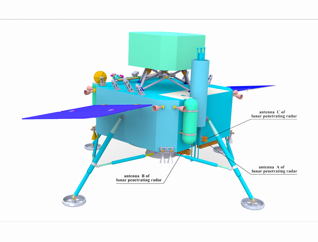
Chang'e-6's Lunar Penetrating Radar Paves the Way for Historic Sampling Mission
At 6:23 a.m. on June 2, the Chang'e-6 lander successfully landed in the pre-selected landing area of the South Pole-Aitken Basin on the far side of the Moon and began the drilling sample and surface extraction with drilling tools and robotic arms. The lunar penetrating radar effective payload developed by the Aerospace Information Research Institute (AIR) of the Chinese Academy of Sciences (CAS) undertakes the task of subsurface detection before drilling and sampling. The lunar penetrating radar serves as an x-ray machine of geologists, allowing scientists to study the layer structure information beneath the Moon’s surface before sampling.
Jun 11, 2024
-
China Focus: AI Algorithm Maps out Detailed Carbon Emissions for City Managers
BEIJING, April 23 (Xinhua) -- A team of Chinese scientists are using artificial intelligence (AI) tech to accurately map out carbon emissions in big cities. This is an attempt that may help urban managers make more evidence-based plans in fighting global warming.
Apr 25, 2024
-
Satellite Helps Distinguish Various Sources of Light
Chinese scientists have turned to science satellite SDGSAT-1 as a tool to manage the impact of modern illumination sources on the urban environment, according to a recent study. The study, conducted by scientists from the Aerospace Information Research Institute of the Chinese Academy of Sciences, was published recently in the International Journal of Digital Earth.
Mar 02, 2024
News & Events